World Biomes Map — free printable diagram
Free geography resource for teachers · CC BY-NC 4.0
About this illustration
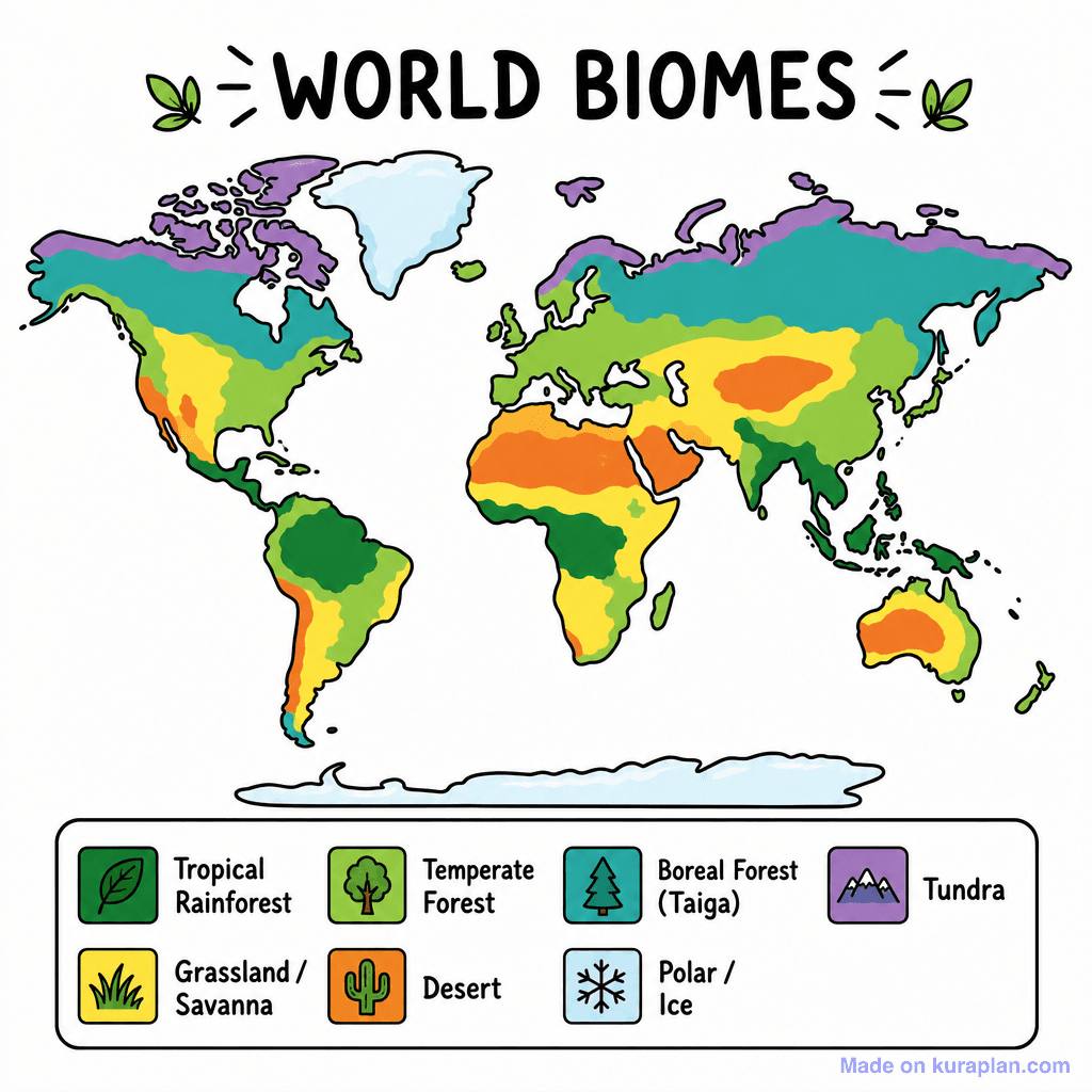
This is a flat illustration of a world map depicting the distribution of Earth's major biomes using a vibrant color scheme. The map is clearly titled "WORLD BIOMES" at the top, with a corresponding legend below outlining seven biome types: Tropical Rainforest, Grassland/Savanna, Temperate Forest, Desert, Boreal Forest (Taiga), Tundra, and Polar/Ice, each with an icon and specific color. This educational image is ideal for teaching geography, environmental science, and biology concepts related to global ecosystems. It suits classroom activities like slide presentations, reference material for worksheets on climate zones, or as a visual aid for discussions on biodiversity and environmental habitats. The visual style features bold outlines and distinct, high-contrast colors, making it easily discernible for K-12 students.
How to use
- 1Right-click the image and choose “Save image as”, or use the download button.
- 2Use it in your classroom worksheets, slides or printables — free under CC BY-NC 4.0.
- 3Attribute as “Image by Kuraplan” or link back to kuraplan.com. Not for commercial resale.
Make worksheets with images like this
Kuraplan's editor has the full image library built in — drag-and-drop into a worksheet in seconds.
Related illustrations
More from World Maps (Thematic)
Browse by subject
18 subjects · 5,159 free illustrations

Maths
1,912 free illustrations
Cross-Curricular
839 free illustrations

Science
818 free illustrations

English
625 free illustrations

Health
201 free illustrations
social_studies
178 free illustrations
Religious Education
140 free illustrations
Music
130 free illustrations

Art
66 free illustrations

Drama
56 free illustrations

social_sciences
48 free illustrations

History
47 free illustrations

arts
26 free illustrations
pe
25 free illustrations
te_reo_maori
24 free illustrations

tech
16 free illustrations

culture
7 free illustrations

languages
1 free illustrations