Scale Ratio Text — free printable diagram
Free geography resource for teachers · CC BY-NC 4.0
About this illustration
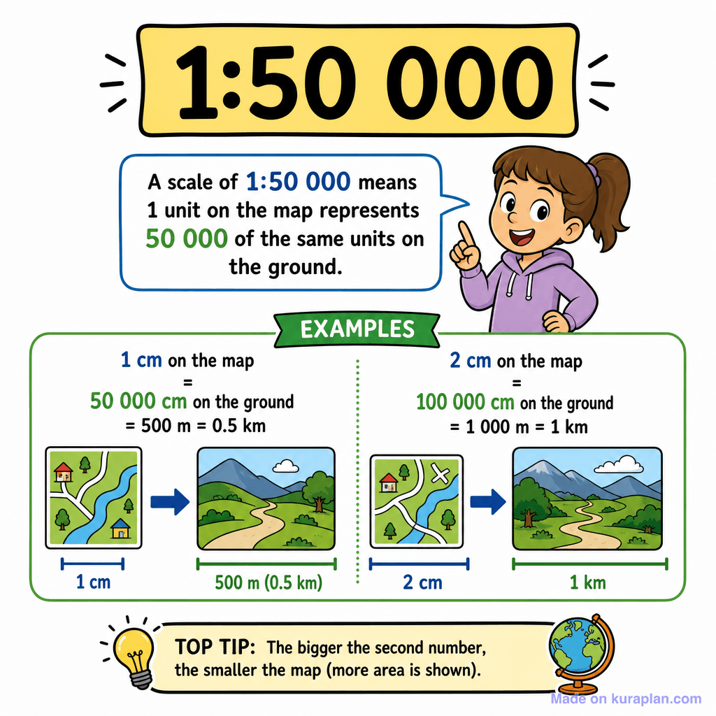
This educational illustration explains the concept of map scale using a 1:50 000 ratio. A cheerful cartoon girl points to a speech bubble defining map scale: '1 unit on the map represents 50 000 of the same units on the ground.' Below this, two clear examples demonstrate how 1 cm on the map translates to 500 m (0.5 km) and 2 cm to 1 km in real-world distances, using simple landscape drawings to visualize the mapping. A 'TOP TIP' at the bottom, accompanied by a lightbulb and globe, explains that a bigger second number in the scale indicates a smaller map covering more area. This resource is ideal for slides or worksheets in primary and middle school geography or mathematics lessons, supporting understanding of map interpretation and proportional reasoning. The visual style is a vibrant, flat, cartoon illustration designed for clear educational instruction.
How to use
- 1Right-click the image and choose “Save image as”, or use the download button.
- 2Use it in your classroom worksheets, slides or printables — free under CC BY-NC 4.0.
- 3Attribute as “Image by Kuraplan” or link back to kuraplan.com. Not for commercial resale.
Make worksheets with images like this
Kuraplan's editor has the full image library built in — drag-and-drop into a worksheet in seconds.
Related illustrations
More from Map Tools & Conventions
Browse by subject
18 subjects · 5,159 free illustrations

Maths
1,912 free illustrations

Cross-Curricular
839 free illustrations

Science
818 free illustrations

English
625 free illustrations

Health
201 free illustrations
social_studies
178 free illustrations

Religious Education
140 free illustrations
Music
130 free illustrations

Art
66 free illustrations

Drama
56 free illustrations

social_sciences
48 free illustrations

History
47 free illustrations

arts
26 free illustrations

pe
25 free illustrations
te_reo_maori
24 free illustrations
tech
16 free illustrations

culture
7 free illustrations

languages
1 free illustrations