World Wind Belts — free printable diagram
Free geography resource for teachers · CC BY-NC 4.0
About this illustration
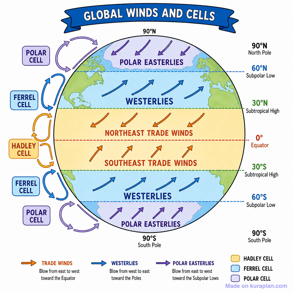
This flat illustration depicts a simplified globe showing Earth's global atmospheric circulation patterns and prevailing winds. The planet is horizontally divided into color-coded latitudinal bands representing different wind belts, with arrows indicating wind direction for Polar Easterlies, Westerlies, Northeast Trade Winds, and Southeast Trade Winds. To the left, three atmospheric circulation cells (Hadley Cell, Ferrel Cell, Polar Cell) are shown with their corresponding flow patterns. The diagram is ideal for K-12 science or geography lessons, suitable for slides, worksheets, or as a reference for understanding weather and climate. Legends explain wind types and cell names, making it excellent for a label exercise or direct instruction.
How to use
- 1Right-click the image and choose “Save image as”, or use the download button.
- 2Use it in your classroom worksheets, slides or printables — free under CC BY-NC 4.0.
- 3Attribute as “Image by Kuraplan” or link back to kuraplan.com. Not for commercial resale.
Make worksheets with images like this
Kuraplan's editor has the full image library built in — drag-and-drop into a worksheet in seconds.
Related illustrations
More from World Maps (Thematic)

Browse by subject
18 subjects · 5,117 free illustrations
Maths
1,894 free illustrations
Cross-Curricular
835 free illustrations
Science
816 free illustrations
English
612 free illustrations
Health
200 free illustrations
social_studies
177 free illustrations
Religious Education
139 free illustrations
Music
128 free illustrations
Art
66 free illustrations
Drama
56 free illustrations
social_sciences
48 free illustrations
History
47 free illustrations
arts
26 free illustrations
pe
25 free illustrations
te_reo_maori
24 free illustrations
tech
16 free illustrations
culture
7 free illustrations
languages
1 free illustrations